Watch the Med
Development WTM site23/09: 154 people brought to Greece and then to prison. One person dead.
24.09.2021 / 15:26 / Aegean Sea
Watch The Med Alarm Phone Investigations – 24th of October 2019
Case name: 20191024-AEG827
Situation: 154 people rescued by oil tanker, brought to Paliochora, near Chania in Crete, and later to Amygdaleza detention near Athens. One person drowned during the rescue, three people were arrested and one person tortured.
Status of WTM Investigation: Concluded
Place of Incident: Aegean Sea
Summary of the Case:
On the 23rd of September at 08:30 CEST, the Alarm Phone was informed about 154 people in a boat in distress in the Ionian Sea. They were in international waters on the Greek Search and Rescue zone, on their way to Italy. The Alarm Phone immediately alarmed Hellenic Coast Guard as well as the Maltese and Italian Coast Guards.
After more than 24 hours, the travelers were rescued by an oil tanker. Coordinated by the Hellenic Coast Guard, the tanker would bring the people to Paliochora on Crete.
During the transfer to the oil tanker, one pregnant woman drowned after falling in the water. According to survivors, three people were arrested for boat driving and later tortured during interrogation.
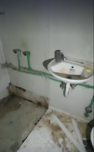
The remaining 150 people were taken to Chania where they were held in a secure place for about 14 days. They were not registered, their rights were not explained to them, neither were they told why they had to stay in prison and for how long.
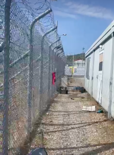
After that, they were brought to detention in Amygdaleza prison in Athens. One month after arrival they were finally registered and informed about their rights there.
After one month of imprisonment, approximately 130 people from the group were released and then put into 2 buses to be taken to a destination that was not communicated to them initially. For the course of the next 10 hours, they received no food. Eventually, they were brought to a camp near Ioannina. The remaining around 20 people were brought to different camps. So finally they are all out of prison.
When we later talked to people on the boat, they told us:
"We, a total of 154 people, young, old, women and children, left for Italy on September 20, 2021 a ship from Izmir, Turkey. Unfortunately, on September 23, our ship broke down in international waters near Italian waters and we start trying to left the ship over the water to survive our self. And finally, by setting fire to a car tire, a big oil tanker ship called Aristofanis came to us and 152 people were rescued after suffering one casualty. Than they bring us to Khaneya Island of Greece and on October 2 they bring us to Aten. As our aim is Italy and we have suffered the greatest psychological damage, I ask you to reach our voice to the humanitarian and immigrants organisations to take exceptional humanitarian action in the case of accepting this immigrant group, and we are ready to cooperate if documents are needed."
It is another example of the hostility with which shipwreck survivors are treated in Greece: deprived of their rights and dignity. We stand in solidarity with them and with all those fighting for freedom of movement.
You can find the tweets here.
positions:
36°00'12.1"N 22°16'32.7"E (timestamp 22/09/2021 5pm CEST)
35°53'04"N 21°35'54" (timestamp 23/09/2021, 4am CEST)
Case name: 20191024-AEG827
Situation: 154 people rescued by oil tanker, brought to Paliochora, near Chania in Crete, and later to Amygdaleza detention near Athens. One person drowned during the rescue, three people were arrested and one person tortured.
Status of WTM Investigation: Concluded
Place of Incident: Aegean Sea
Summary of the Case:
On the 23rd of September at 08:30 CEST, the Alarm Phone was informed about 154 people in a boat in distress in the Ionian Sea. They were in international waters on the Greek Search and Rescue zone, on their way to Italy. The Alarm Phone immediately alarmed Hellenic Coast Guard as well as the Maltese and Italian Coast Guards.
After more than 24 hours, the travelers were rescued by an oil tanker. Coordinated by the Hellenic Coast Guard, the tanker would bring the people to Paliochora on Crete.
During the transfer to the oil tanker, one pregnant woman drowned after falling in the water. According to survivors, three people were arrested for boat driving and later tortured during interrogation.
The remaining 150 people were taken to Chania where they were held in a secure place for about 14 days. They were not registered, their rights were not explained to them, neither were they told why they had to stay in prison and for how long.
After that, they were brought to detention in Amygdaleza prison in Athens. One month after arrival they were finally registered and informed about their rights there.
After one month of imprisonment, approximately 130 people from the group were released and then put into 2 buses to be taken to a destination that was not communicated to them initially. For the course of the next 10 hours, they received no food. Eventually, they were brought to a camp near Ioannina. The remaining around 20 people were brought to different camps. So finally they are all out of prison.
When we later talked to people on the boat, they told us:
"We, a total of 154 people, young, old, women and children, left for Italy on September 20, 2021 a ship from Izmir, Turkey. Unfortunately, on September 23, our ship broke down in international waters near Italian waters and we start trying to left the ship over the water to survive our self. And finally, by setting fire to a car tire, a big oil tanker ship called Aristofanis came to us and 152 people were rescued after suffering one casualty. Than they bring us to Khaneya Island of Greece and on October 2 they bring us to Aten. As our aim is Italy and we have suffered the greatest psychological damage, I ask you to reach our voice to the humanitarian and immigrants organisations to take exceptional humanitarian action in the case of accepting this immigrant group, and we are ready to cooperate if documents are needed."
It is another example of the hostility with which shipwreck survivors are treated in Greece: deprived of their rights and dignity. We stand in solidarity with them and with all those fighting for freedom of movement.
You can find the tweets here.
positions:
36°00'12.1"N 22°16'32.7"E (timestamp 22/09/2021 5pm CEST)
35°53'04"N 21°35'54" (timestamp 23/09/2021, 4am CEST)
Last update: 11:50 Dec 18, 2021
| Credibility: |  |
 |
0 |
Related Reports
16:17 Sep 02, 2022 /
Eastern Med Kms
01/09: 37 people from North Lebanon pushed back to Turkey while trying to reach Italy
11:48 Aug 26, 2022 /
Eastern Med Kms
25/08: Unclear Outcome for a Boat in Distress south of the Peloponnese
11:35 Aug 25, 2022 /
Eastern Med Kms