Watch the Med
Development WTM site07/06 Alarm Phone alerted to 1 emergency situation in the Aegean Sea, Samos
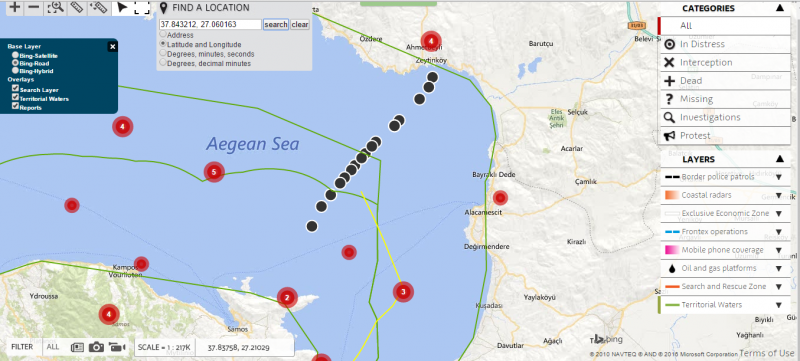
08.06.2016 / 17:23 / Samos, Aegean Sea
Watch The Med Alarm Phone Investigations – 7th of June 2016
Case name: 2016_06_07-AEG253
Situation: Alarm Phone alerted to 1 emergency situation in the Aegean Sea
Status of WTM Investigation: Concluded
Place of Incident: Aegean Sea
Summary of the Case: On Tuesday the 7th of June 2016, at 4.25am, the Alarm Phone shift team received a Facebook message by a contact person, alerting us to a distress case in the Aegean Sea. Shortly afterwards we received the phone number of some of the travellers as well as their GPS coordinates, showing the boat still close to the Turkish coast. We were informed that there were 45 people on board who spoke Kurdish and Arabic. At 4.44am we tried to reach the boat but the call became quickly interrupted. We learned that our contact person was in regular contact with them. He informed us that the travellers were ok and not in an acute distress situation. Their boat kept moving toward Samos Island as the many GPS positions that we received showed. At 5.34am we found out that there were 9 children and 1 sick infant amongst the group.
Our shift team kept monitoring the trajectory of the vessel and, once it had crossed into Greek waters, we informed the Greek coastguards at 6.14am. They noted down the coordinates as well as the phone number of one of the travellers who had agreed to share his number with the Greek authorities. After receiving updated coordinates, we reached out to the Greek coastguards again and forwarded the boat’s new position. They confirmed that they had sent out a patrol boat to the location.
At 6.48am our contact person informed us that the boat-people were able to see the coastguard vessel approaching. At 7.11am the Greek coastguards confirmed to us that they were escorting the vessel to the shores of Samos.
At 8.06am we learned that the people had been transferred onto the patrol boat of the coastguards. At 9.58am, the Greek coastguards confirmed that the group had been brought to Samos, which was also confirmed by our contact person later on.
Last update: 17:31 Jun 15, 2016
| Credibility: |  |
 |
0 |
Related Reports
18:35 Aug 04, 2017 /
Aegean Sea Kms
03/08: 37 people including 11 children reached the Greek island of Samos
19:45 Nov 18, 2018 /
Aegean Sea Kms