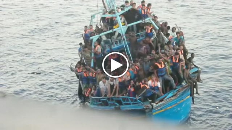
Between 30-181 people die of suffocation, drowning and/or stabbing south of Lampedusa
20.07.2014 / 20:05 / South of Lampedusa
15.07.2014: 30-181 deaths. Several major news-outlets first report of the death of 30 migrants on a fishing boat carrying more than 600 people, south of Lampedusa in waters between Libya and Malta. The boat was initially assisted by the Danish tanker Torm Lotte and then by Italian and Maltese coast guard and navy vessels. The apparent cause of death was the inhalation of engine fumes. One person died on the way to hospital. Survivors were taken to Italy and two of them were brought to a hospital in Palermo. So far the Italian navy has not released information on the nationalities of the dead and the survivors.
However, between the 22nd and 25th of July the IOM, UNHCR and other news outlets report that more than 750 people had been on that boat. Survivors estimate that between 110-151 people had been stabbed and/or thrown overboard during the journey, with many also dying during the rescue operations. The Italian police has arrested five men accused of murder.
http://www.unhcr.org/53d0cbb26.html
http://www.bbc.co.uk/news/world-europe-28082969
http://www.theguardian.com/world/2014/jun/30/thirty-dead-bodies-found-migrant-boat-italy
http://www.repubblica.it/cronaca/2014/07/22/news/i_naufraghi_superstiti_barcone_strapieno_ne_sono_annegati_180-92107078/
http://www.iom.int/cms/en/sites/iom/home/news-and-views/press-briefing-notes/pbn-2014b/pbn-listing/migrants-tell-of-mass-murder-on.html
http://www.focus.de/panorama/welt/grausiges-blutbad-an-bord-augenzeugen-181-fluechtlinge-sterben-vor-lampedusa_id_4007600.html
Last update: 15:51 Feb 10, 2015
| Credibility: |  |
 |
0 |
Related Reports
22:52 Oct 11, 2013 /
Central Mediterranean Kms
Over 200 die after shooting by Libyan vessel and delay in rescue
17:38 Jun 08, 2015 /
Off the coast of Libya Kms
Large group of Syrian refugees in distress in the Central Med, rescued
10:17 Aug 02, 2015 /
Central Mediterranean Sea, Off the coast of Libya Kms